During our Thanksgiving break of 2008, we started discussing what vacation we might want to take in 2009. Two different options emerged: a trip to the Yellowstone area, or a trip to the Grand Canyon.
We spent several nights talking it over, and doing internet research. We also checked out a number of books from the library.
The following are some of the more interesting pages we found about hiking in Yellowstone:
The following are some of the more interesting pages we found about hiking in the Grand Canyon:
Two of the books we particularly liked were Hiking Grand Canyon National Park, by Ron Adkison (ISBN 0-7627-36577), and Yellowstone Trails, by Mark C. Marschall.
We began to plan a trip out west for October or early November of 2009. We decided that part of the trip would be a stop at the Grand Canyon. Another part would be a stop in Vegas to visit some friends. We also wanted to see see Hoover Dam and other related sights at the same time. Other than that, we did not nail down any details.
A few days into our research, the idea began to emerge that we should take a backpacking trip rather than a normal "sightseeing vacation". (Ken's brother Mark had expressed an interest in backpacking the Grand Canyon as far back as 2001.)
The last time Ken did any backpacking was as a Boy Scout, a lot of years ago. Julie has never done any backpacking. So, any backpacking trip was going to be a challenge, Taking on the Grand Canyon sounded a little suicidal. We took a few weeks to seriously think it over before finally deciding to try it.
In the end, our decision to do the Grand Canyon instead of Yellowstone was partly due to the challenge of it, partly because we wanted meet Mark there, and partly because of the lack of bears in the Grand Canyon. :)
Once deciding on this plan, we did a bunch of research, and finally decided to hike down and up the canyon starting at the south rim. The ascent and descent cover about 1 mile of vertical distance in about 10 miles of hiking distance, with a grade something like 14% on average.
The best months to hike in the canyon are supposed to be October and early November, and then late March and April. These months are cool enough to avoid major heat-related problems, but are not cold enough (usually) that we would have to hike in winter clothing. We technically could hike in the summer, but it is much more challenging, and the park service recommends not even moving between the hours of 10:00am and 4:00pm due to the heat.
Here are a few pages that discuss Grand Canyon weather:
Initially, we had considered a shorter hike with a stay at the Phantom Ranch dormitory at the canyon bottom, which we probably could have done with a technical daypack (i.e. no tent, no sleeping gear, no cooking gear, etc.). However, the dormitory books out 14 months in advance and it was already 100% full past the end of November 2009. Our second option was to ride down on a mule. Leaving aside other considerations, this can't work because the mule load limit is a strict 200 pounds including clothing, and Ken weighs more than that. A third option was to hike but to have the mules carry some of our gear. This costs $65 each way for a smallish bag, so it is a viable, if expensive, option. The final option was to turn the trip into a real backpacking trip, where we carry everything we need including most food, clothes, sleeping gear, tent, etc.
(Phantom Ranch does provide meal service even for people who are not staying there. They offer a big breakfast, sack lunches, and several different dinners. In practice, it seems to be rather difficult to get a reservation for breakfast or dinner, so the best we'll be able to do is rely on them for a few lunches.)
After a lot of consideration, we decided that the final option would be the most practical and most enjoyable way to get to the bottom of the canyon and back up. So, that's what we're planning for.
In late January, Julie finally managed to make phone contact with a ranger, who answered some of our more detailed questions about scheduling and permitting. First, we were able to clarify that the "nights of camping" restriction, which we found a little confusing. Per the current rules, we can camp two nights per campground per hike. So, it is OK for us to camp two nights at Bright Angel before heading back up to the rim.
Second, we got some details about how tight the schedules usually are. The ranger told Julie that we have a good shot at a permit in October as long as we can be flexible. October is one of their busiest months. The Cottonwood campground is very popular in October. It's the most likely reason permits are rejected. November is much less crowded than October, and she recommended trying November instead of September (September is much hotter). After this conversation, we decided that we still wanted to aim for October, to avoid the heat but reduce the chance of ice on the trail.
There is a 4-month lead time for getting a back-country hiking permit. So, to get a reservation for October 2009, you have to fax in a permit request on June 1, 2009. All of the faxes are collected together and a lottery is done starting at the end of the day on June 1.
On our permit request, we asked for a 4-day itinerary in mid-October: a route down South Kaibab Trail and back up Bright Angel Trail, with two nights at Bright Angel Campground at the bottom and one night at Indian Garden Campground on the way up. Then, we checked the checkboxes telling NPS that they could vary our request two different ways: either by changing the start date to any date between October 1 and October 31, or by cutting one day out of our permit (making it one day down, then two back up).
Faxing the request in turned out to be an adventure. The phone was busy for hours and hours the morning of June 1. Julie put the fax into the machine at work and set it for the maximum number of retries. She had to do this 3-4 times before finally getting through.
Our backcountry permit arrived about 3 weeks later. We got a slot from Sunday, October 24 to Wednesday, October 27 with our original requested route. This is later in the season than we might have hoped for, but at least we got something.
Once we got our backcountry permit, we rushed to make meal reservations at Phantom Ranch. Unfortunately, we were not able to reserve dinner — they were 100% booked for both dinner and breakfast. We did decide to take two days of bag lunches, just to cut down on the amount of food we would have to carry on the way down.
We found the following pages useful:
One of the books we liked was Conditioning for Outdoor Fitness by David Musnick and Mark Pierce.
Equipment is discussed further on the prep page. Gear rental is discussed on the rental page.
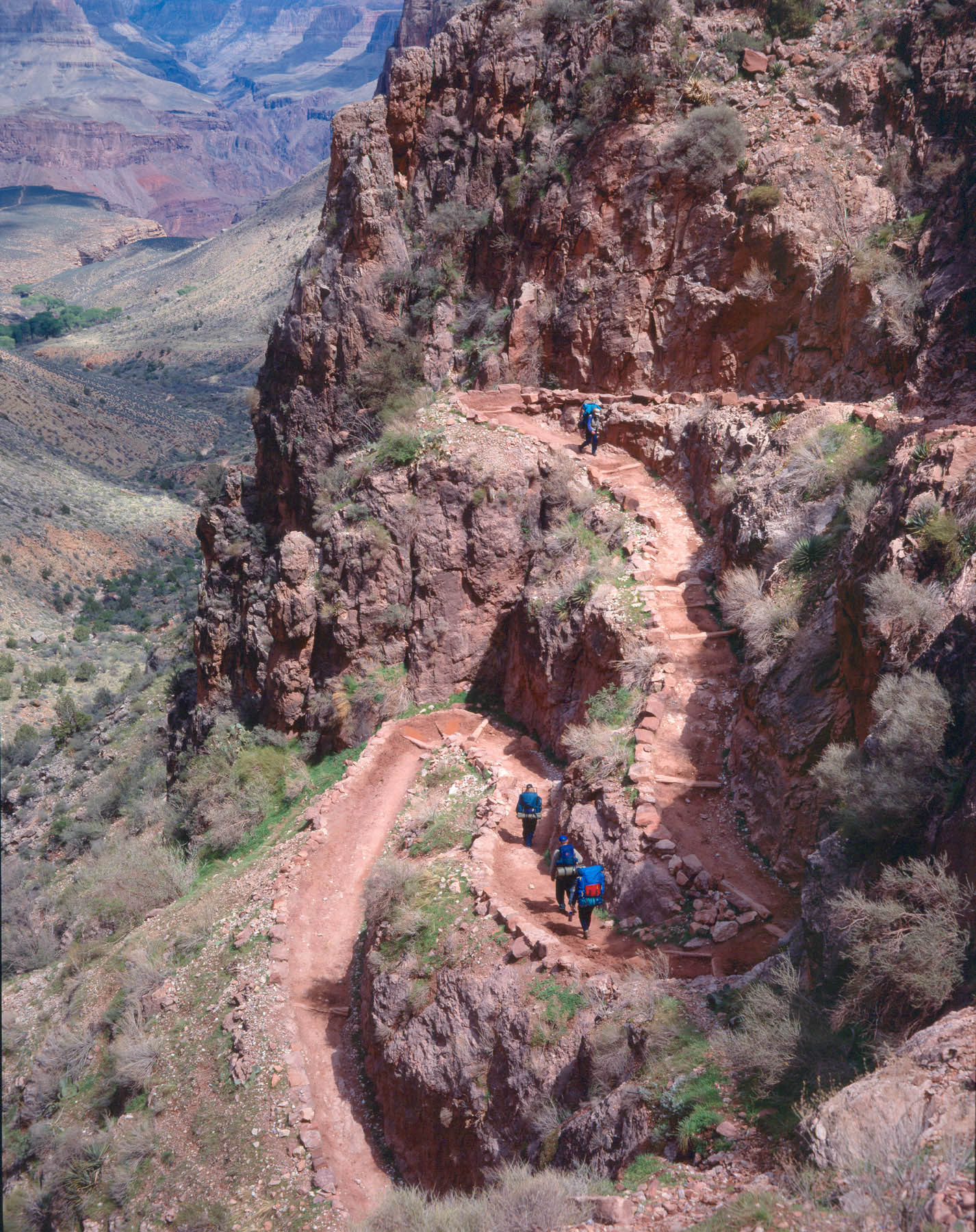
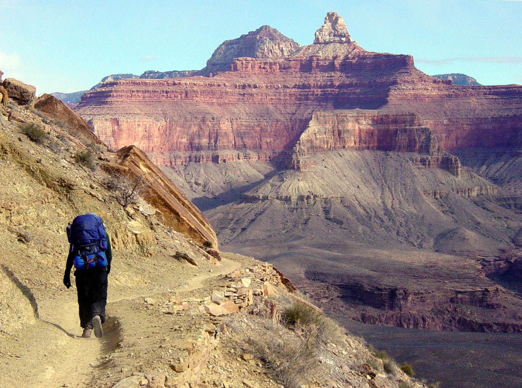
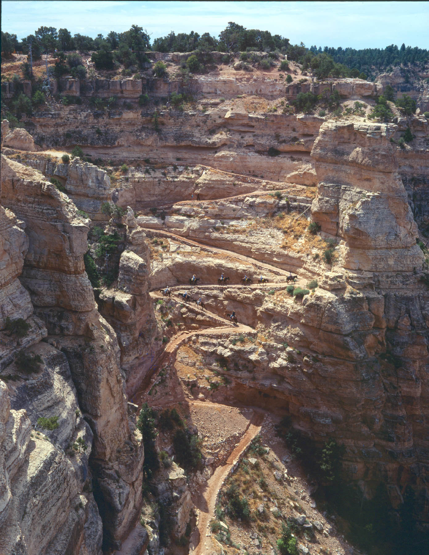
Ken has a fear of edges — he doesn't mind heights per se, but does not like being near cliff edges very much. Toward the beginning of our research, We talked to Ken's friend Sean, who has hiked the canyon before. We asked Sean how close to the edge the trail generally is. Sean had this to say:
It varies quite a bit throughout the trail, however you will often be right on the edge on the upper switchback portion of the trail, and once you get farther down in you usually aren't on the edge of anything super steep since you're already at the bottom ... The steepest drop-offs are closer to the top, I think in one of those thick red or white layers of rock just down from the top...You also need to step off the trail occasionally to let mule trains pass, however if you are paying attention you usually can see them coming way in advance and you can just stop at the first good opportunity and wait rather than balancing on the edge at the worst parts.
He also helpfully sent along links to these three pictures, which he says do not really accurately show the steepest or narrowest bits, but which he thinks are probably better than nothing:
In January, when Julie talked to the ranger about permit questions, she also managed to get some answers on this subject. The ranger said that the trail is 4-6 feet wide. Bright Angel is the best because it is down a side canyon and has lots of switchbacks. South Kaibab is a ridgeline trail, which would be somewhat worse. North Kaibab has parts that are terrible for people with a fear of heights. She tells people with a fear of heights not to go on North Kaibab, and she sometimes sees people really hugging the inside of the trails.
After this discussion, we decided to go down South Kaibab and back up Bright Angel.